Map Matching, Sep. 2023 – Present
I work on improving how we turn raw location-based service (LBS) data into clean and reliable human travel trajectories. Using a method based on Hidden Markov Models (HMM), I match each noisy GPS point to the most likely road on a digital map (such as OpenStreetMap).
To make this process accurate and easy to use across different cities and datasets, I developed NOVAMATCH, a unified pipeline that automatically cleans LBS data, performs map matching, and produces high-quality, complete travel paths. NovaMatch is now used to generate our lab’s Complete Trip data for large-scale mobility analysis.
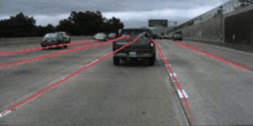
Robust Lane Detection through Self Pre-training with Masked Sequential Autoencoders, Sep. 2021 – Aug. 2022
Objective: To develop robust lane detection neural network model that can tackle challenging scenes
Delivery: A research paper titled Robust Lane Detection through Self Pre-training with Masked Sequential Autoencoders and Fine-tuning with Customized PolyLoss. And the Vision-Based Lane Detection System With Self-supervised Pre-training Through Masked Sequential Auto-encoders (VLD_SP-MSAE) pattern.